-
") NewsTajikistan: Sarez Lake monitoring and Early Warning Systems (EWS)
NewsTajikistan: Sarez Lake monitoring and Early Warning Systems (EWS)
Tajikistan: Sarez Lake monitoring and Early Warning Systems (EWS)
February 2021
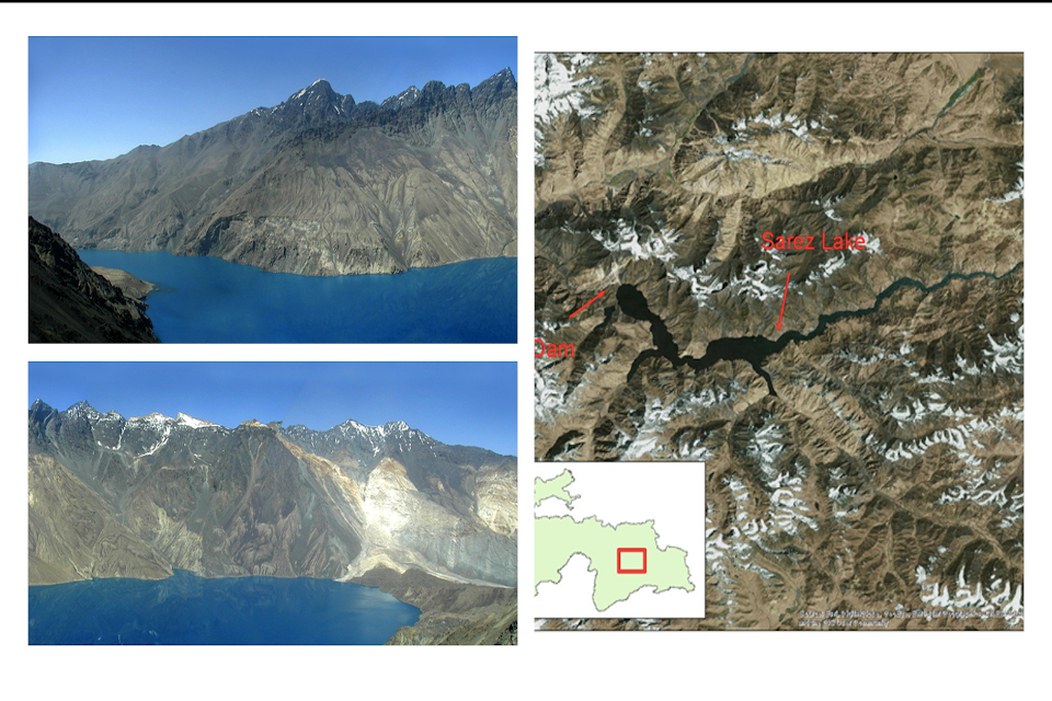
Sarez Lake is located in the Rushon District of the Gorno-Badakhshan province, Tajikistan. The lake was created by a massive landslide triggered by a high intensity earthquake in 1911. The landslide created the Usoi Dam (650m high), the highest dam in the world, either natural or man-made. The lake that formed behind the dam initially rose at a rate of approximately 75m/year and drowned the village of Sarez, after which it was named. The lake has no natural outlet and as a result there is concern that the failure of the rubble heap dam would have a significant impact of the habitants who live directly downstream of the natural Usoi Dam.
Within the framework of the Lake Sarez Risk Mitigation Project (LSRMP), CAE and its local partner will be responsible for a complete replacement of the current monitoring and Early Warning System (EWS), established between 2003 and 2006, as it is approaching the end of its design life. The new monitoring and EWS is expected to protect the 17 villages located along the Murgab river and the Bartang river and reduce the vulnerability of the population to natural disasters, including the potential outburst of Lake Sarez.
The contract scope includes the supply, installation, and commissioning of the monitoring and EWS that will enable real time and reliable monitoring of Sarez Lake’s right and left banks, as well as upstream and downstream rivers for data gathering, Early Warning System activation and communications with required units.
The approach to the early warning and monitoring system was based on triggering effects and the concatenation of possible triggering events for the Usoi Dam and the Sarez Lake, respectively. The main triggering events considered were a right bank slide, an earthquake affecting the dam or causing an increase in water level in the lake, the dam overtopping by a wave due to either a significant landslide into the lake proper or a glacial lake outburst above the lake, and the internal disturbance of the dam. Since the 2000-2006 analysis, it has been noted that a left bank slide area in the lake has been documented as a primary concern. Most of the triggering events are not mutually exclusive.
The triggering events to be monitored in the contract:
- Right bank slide;
- Left bank slide;
- Earthquakes;
- Lake Sarez level;
- Community EWS;
- EWS System, Communications and Data Centre (SCADA);
- Communication center at Sarez Lake and at Dushanbe.
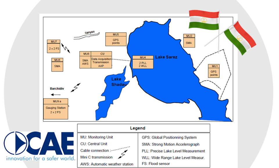
The Sarez Lake monitoring and EWS will be composed of:
- n.4 GPS points: to be used for manual observations for the both right and the left bank slide;
- n.3 strong Motion Accelerometer (SMA): to monitor seismic activity relating to earthquakes;
- n.2 Sarez Lake Level Measurements: to monitor water level and wave height by means of submersible pressure sensor, connected to one CAE Mhaster datalogger and solar power charging system;
- n.1 automatic Weather Station (AWS): to monitor local weather conditions of Sarez Lake with a complete set of sensors including thermo-hydrometer THS, rain gauge PG2, snow depth sensor ULM30/N, wind speed and direction, solar radiation, and atmospheric pressure, etc.;
- n.4 hydrological stations above Lake Sarez and n.2 hydrological stations below the lake, managed by 6 Mhaster dataloggers;
- n.30 siren alarm stations: composed of five-meter tower with two manually-triggered sirens, solar power, charging system;
- n.30 portable radio and Sat-phone: for communication between Sarez Lake and Dushanbe Communications centers and downstream Community siren control centers;
- n.1 EWS PC-based SCADA: equipped with CAE software suite, including DATALIFE, AEGIS, PatrolME, etc. for collecting data from hydrological stations, Sarez Lake water level, SMA and trigger alerts to communication centres;
- n.1 drone: for Remote monitoring of sites in the lake proper and below the dam;
- n.1 ADCP and n. 1 salt dilution technique equipment with Surveyors Level: for Discharge measurements and direct water level readings.
In addition to the supply of the specialized equipment, CAE will provide a full range of services such as project design, system integration, equipment installation and commissioning, transport, testing as well as classroom and on-site technical training, etc.
CAE will continue to update you over the next few months about the project’s developments.
Back to the news index