-
 NewsTWO MORE LANDSLIDE MONITORING SYSTEMS UNDER IMPLEMENTATION: ONE STEP FORWARD TO A MULTI-HAZARD APPROACH
TWO MORE LANDSLIDE MONITORING SYSTEMS UNDER IMPLEMENTATION: ONE STEP FORWARD TO A MULTI-HAZARD APPROACH
January 2013
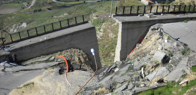
Following the successful experience of the real-time monitoring system installed on Cirò landslide (KR), where the solutions proposed by CAE are still proving their efficiency and reliability, the Civil Protection of Regione Calabria chose once again our company for monitoring other two high-risk landslide areas.
The new real-time monitoring systems, completely based on Wireless Sensor Network technology, are in the process to be set in Papanice (KR) and Bova Marina (RC) and they are going to be integrated into the existing regional network, managed by the regional Multi-risk Functional Center of Calabria. These new systems, together with that one working in Cirò, represent the first network completely based on WSN for landslide monitoring purpose in Italy.
CAE’s monitoring systems are a complete and cutting edge solution in landslide monitoring field, able to work even in the harshest environments and allowing to remotely control all the most representative parameters for slope stability. Moreover, the possibility to monitor the meteorological and geotechnical parameters together in the same site enables to investigate the close relationship between them, which is a key requirement for a complete understanding of a landslide.
Besides the traditional meteorological data, though very important in landslide triggering, the Civil Protection will be able to monitor the following geotechnical parameters: deep movements, thanks to a set of in-site inclinometers, surface movements and pore pressure within the instable soils. Furthermore, a real-time camera on each site will provide a visual feedback to any critical issue highlighted by instrumental data.
The meteorological and geotechnical data will be available in real-time at the Multi-risk Functional Center control room. That will allow a suitable assessment of potentially hazardous situations linked to landslide dynamic and the quick activation of Civil Protection emergency plan.
The partnership between CAE and the authorities responsible for public safety get every day stronger, toward a new monitoring concept which does not deal the natural phenomena one by one, but involves inside a unique network all the physical a chemical parameters of the environment surrounding us leading to a real multi-risk approach.