-
 NewsClimate is changing. Guido Bernardi tells us how multi-hazard systems allow us to optimize investments in prevention
Climate is changing. Guido Bernardi tells us how multi-hazard systems allow us to optimize investments in prevention
November 2017
Why has CAE invested in "multi-hazard" technologies?
We wanted to think about the needs of Italian public authorities and to give them the opportunity to turn their investments in prevention more effective. Studies published by the World Meteorological Organization prove that the average savings produced by 1 Euro invested in the risk prevention connected to extreme meteorological conditions rage between 4 and 36 Euros during the following years, depending on the affected territory and the methodology of accounting. Apart from these economic savings, we should add an increased security for the citizens, which is important as much as it is difficult to monetize.
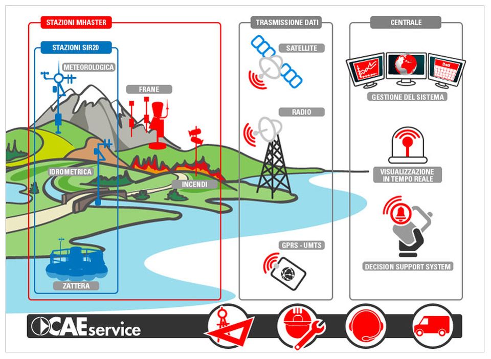
With the Mhas technologies (Multi-Hazard System), any investment planned by a public authority in order to reduce "flood risk", which is the most common risk associated with meteorological conditions, has a positive effect on the reduction of other risks, too. Since one of the main skills of our company has always been the ability to create real-time monitoring systems for those phenomena that are traditionally associated with hydrological and meteorological fields, extending the scope of our activity to "landslides", "forest fires" and "quality of the water resource" has been a natural evolution. In times of straightened circumstances for our public authorities, investing in multi-function technologies is an important opportunity.
A single technology that helps tackle drought, forest fires, landslides and floods: how is it possible?
Locating a fire when its dimensions are still reduced, and therefore having the possibility to extinguish it with modest efforts, is now possible due to the use of high definition thermal cameras, as well as to the implementation of the appropriate algorithms. The more you are able to know in real time the meteorological conditions of an area affected by a fire, the more the prediction of how the fire front could expand in the following hours after its detection is accurate: temperature and humidity of air and soil, atmospheric pressure, rainfall and, above all, wind direction and speed. Even before the fire starts and is detected, when we are still in a phase of prevention and non-emergency management, these data provide a set of "risk indicators" that describe the probability of a combustion and the relevant danger.
With the same meteorological information, integrated with the measurements of the hydrometric levels and the flow of the water courses, you can understand flood events and, therefore, manage them. Through an adequate modelling, it is possible to understand how a river flood will evolve. In other cases, when the phenomenon is particularly fast, as it occurs to some streams in case of particularly intense and concentrated rainfall, field equipment can be programmed to make decisions based on the events, with no need to wait for human intervention, which could come too late. This logic, integrated with locally-installed technologies, allows us to activate an alarm (traffic lights, sirens, barriers ...) in case of debris flows towards an inhabited area or a flooded subway in a urban area.
Many kinds of landslides can also be "observed" in real time in order to determine both its past and prospective evolution. We will need to integrate the already mentioned meteorological measurements with geotechnical ones, collected at the site affected by the instability. In this case, even more than in the previous ones, the information rarely allows the geologist to have a deterministic and definite prediction of how the phenomenon will evolve hour by hour, but it will be possible to evaluate the hazard of an instability in a given period. Once again, we will be able to make crucial decisions for the safety of the citizens.
Therefore, it seems clear that all the damages caused by these phenomena can be better reduced if we receive real-time information from the territory. Being able to use the same field infrastructure, the same transmission tools and the same IT equipment to handle all these measurements, calculations and information simplifies pretty much our task.
We often hear about "interoperability of technologies." What does this mean for CAE and how does it affect multi-hazard applications?
In the IT field, interoperability is the ability of a system or IT product to cooperate and to exchange information or services with other systems. For CAE, it is an irreplaceable characteristic of the systems we offer. Applying physical interfaces and standard protocols, implementing widespread data recording formats, and massive implementation of web-based technologies are all designed to promote interoperability with third-party technologies.
There are many advantages that this approach guarantees to our clients. First of all, a system offered by CAE can always integrate technological components, such as already existing sensors produced by any other manufacturer. If a public authority uses MHA technologies, virtually it does not waste any of the investments it has previously made, and it is sure that the new implemented technologies will result from the integration of the best solutions on the market.
Moreover, interoperability as a wider concept guarantees a very high degree of flexibility in the architecture of monitoring and alert systems. Several organizations and bodies, such as Regional Functional Centres, municipal authorities, University Departments, and maybe even National Parks, are often involved in the management of a critical scenario. In such cases, it is crucial to make the collected data easily manageable by all the people involved. Some users may just need to check the data on a fixed location or mobile device, while others may need to integrate measures into an already existing database developed with their own technologies. Finally, someone may want to use the regional radio networks of the Civil Protection in order to increase the security and the reliability of the entire solution. Today, all this has become possible and easier thanks to interoperability.
Extending the scope of your activity to multi-hazard systems is an important step for your company. How did you prepare for this?
We have always structured our work in order to provide reliable solutions, that are especially effective in emergency situations, when meteorological conditions are more difficult. We have a department that intervenes remotely, as well as field technicians ready to move anywhere there is a system provided by our company, always 24 hours a day, 7 days a week, and 365 days a year. Even in the design and implementation of solutions we always pay attention to reliability and use technologies that are always independent from external power supply and equipped with transmission technologies that are, if possible, redundant and aimed at meeting the specific needs of our customers.
But this is not enough. Investments specifically aimed at expanding the scope of activity from the traditional "hydrometeorological" field to a "multi-hazard" one began in 2010, with a massive work on the development of the Wireless Sensor Network dedicated to landslides. Then, they continued with the launch of the "Mhas" technology in 2013, with its automatic Mhaster station, and are still continuing with many other innovations and news, that we also discuss here on this Magazine from time to time.
Since CAE's concept is to offer not just technology, but also a high added-value service, we are working hard on many other aspects: we have strengthened the team thanks to a staff specialized on specific topics; moreover, we are now equipped with specialized tools and have ongoing collaborations with companies, universities and research centres specialized in each target area.
Guido Bernardi
Business Development Manager
Back to index